
METRO Bus Shelters Heat Vulnerability
A spatial prioritization model developed to identify unsheltered bus stops most vulnerable to extreme heat exposure and support strategic shelter investments throughout Houston's East End.
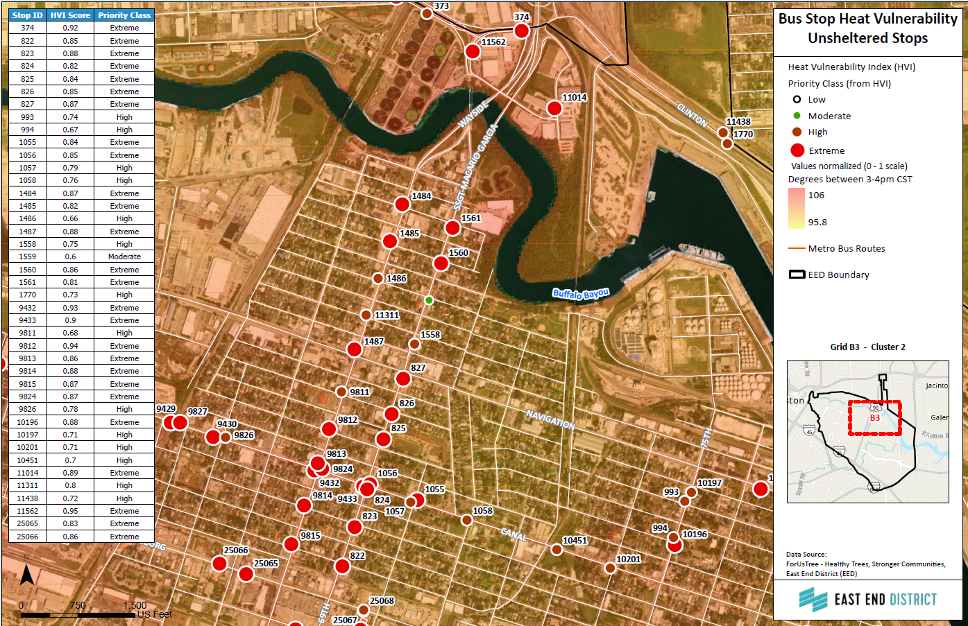
METRO sought to identify bus stop locations where riders experience the greatest exposure to extreme heat while waiting for transit service. Gold Axis developed a Heat Vulnerability Index (HVI) to evaluate all 397 active bus stops within Houston's East End by integrating modeled afternoon heat conditions, tree canopy characteristics, and shelter availability. The assessment produced a corridor-based prioritization framework that supports future shelter deployment, field validation, and long-term transportation infrastructure planning.
Planning Insights
Most Bus Stops Lack Shelter Infrastructure
Approximately 75% of the East End's 397 active METRO bus stops are unsheltered, leaving riders exposed to Houston's summer heat. Rather than being randomly distributed, these stops cluster along major transit corridors where pedestrian activity is highest, creating opportunities for coordinated infrastructure improvements instead of isolated installations.
Heat Vulnerability Extends Beyond Temperature Alone
Heat exposure was evaluated using a custom Heat Vulnerability Index that combined modeled afternoon heat conditions, tree canopy density and height, and shelter availability into a single normalized score. This approach identified locations where multiple environmental factors compound rider exposure instead of relying solely on air temperature.
Wayside Drive Emerged as the Highest Priority Corridor
The analysis identified the Wayside Drive corridor (Cluster 2) as the highest priority investment area. Multiple consecutive bus stops received High and Extreme vulnerability scores due to the combined effects of limited tree canopy, elevated afternoon heat, and the absence of shelter infrastructure. Rather than isolated problem locations, the study revealed a continuous corridor of elevated risk suitable for phased infrastructure improvements.
Corridor-Based Planning Maximizes Investment
Rather than recommending improvements one stop at a time, the assessment demonstrated that corridor-level planning would produce greater operational efficiency. Concentrating investments within high-priority corridors allows engineering review, ADA compliance, and shelter deployment to occur as coordinated infrastructure projects rather than isolated upgrades.
Technical Approach
Gold Axis integrated modeled afternoon heat index data, high-resolution tree canopy coverage, tree height, and METRO bus stop infrastructure into a unified geospatial analysis. Environmental variables were normalized and combined to produce a Heat Vulnerability Index (HVI) ranging from 0 to 1, enabling every unsheltered bus stop to be objectively ranked by relative heat exposure. A companion map series was then developed to support engineering review, field validation, and phased implementation planning.